North
Maluku Regional Tourism
North Maluku
North Maluku
North Maluku province has always known by the world community during the reign of the empire in 1618 as a producer of spices, especially clove and nutmeg. This area had been a VOC control center and a base defense between the Japanese and Allied troops during World War II.
That's why young people in the province can be found a number of historical relics such as forts either still intact or the ruins of war and some equipment scattered in several areas such as Morotai, and Kao.
North Maluku has about 353 large and
small islands with the island of Halmahera, the largest island in the region.
Two of the most famous island in North Maluku since the colonial period is the
island of Ternate and Tidore. Two of the island is famous in the past with the
nickname as the Spice Islands (Spice Islands).
On the island of Ternate and Tidore
is Portuguese and later Dutch came and settled for the first time in the
archipelago. Ternate and Tidore attract the attention of Portuguese and Dutch
traders because of the abundant production of cloves. The remains of buildings
from the colonial period as the fortress are still numerous in the second
island.
The island of Ternate and Tidore
surrounded by black sand beach with a beautiful panorama of volcanic mountains
and other tropical island scenery is impressive.
Before the arrival of Europeans to
the Moluccas, Ternate Sultanate is the ruler of the most important and most
influential in the Moluccas. Effect of Ternate Sultanate spread to the South up
to the Ambon; to the west to Sulawesi, and to the East to Papua. Sultanate of Ternate
Sultanate was prosperous because of the production of cloves. This allows the
empire to build a powerful military force in the region.
In 1511, the Portuguese arrived and
became the first Europeans to settle in the region and implementing the practice
of the spice trade monopoly. In 1576 the people of Ternate expel the
Portuguese. Five years later the British ships led by Francis Drake also comes
rerlalu but apparently they are not interested in developing business in this
area. Other nations are the Netherlands who came to build a monopoly of trade
in the year (1599) and also Spain in the 17th century.
Ternate is an urban background
Gamalama Volcano (1721 m) which often cause smoke and roar. Market area near
the terminal bemo is one of the busiest locations, crowded and also draw in
Ternate. Some traders in the currency market offers ancient coins, although the
Netherlands is still necessary to prove its authenticity. Tourism offices in
the city is located on Jl Heroes of the Revolution where tourists can obtain a
variety of travel brochures and tourist maps. Ternate city has several tourist
sites of interest to visit such as Kedaton Sultan and Fort Orange.
Kedaton
Sultan of Ternate is a palace built on November 24,
1813 by Sultan Muhammad Ali on the hill Santosa Lemons with a total area of 445,560 m2. Octagonal with two steps, especially on the left
and right front.
This building depicts a lion who was
sitting with two front legs menopan head. In the kedaton contains relics of the
empire's worth of history like a crown, handwritten Koran first and oldest in
Indonesia and other war equipment.
Crown Prince Sultan of Ternate, the
main attraction there was a crown of hair with a gold gemstone jewelry, silver,
diamonds, diamonds, stones mira, emerald, carnelian and sfafir. Uniquely
decorative crown hair has always grown and trimmed at the Eid al-Adha in a
traditional ceremony. Ternate society called the crown in the local language is
Istampa.

Mosque
of the Sultan of Ternate is
located about 100 meters from Kedaton. Its construction began in 1606 during
the reign of Sultan Saidi Barakati and then continued by Sultan Musafar Hamza
Sultan and completed by the year 1648 with the composition of a material made
of stone structure.
The adhesive used a mixture of tree
bark Kalumpang to form a rectangular-shaped building where the roof adopts
overlapping shapes overlap pyramid and each filled with 360 carved fruit bars
according to the number of days in a year.
Orange
fortress built by the Dutch in 1607 and also
serves as the headquarters of the VOC until the year 1619 before the VOC
headquarters moved to Batavia. The fort also serves as the residence of Dutch
governor in Ternate. Today, the fort became the headquarters of Indonesia military
and police, but tourists are allowed to see the grandeur of this castle.
Area around the city of Ternate has
some interesting tourist sites to visit. Available roads that surround the
island of Ternate, so most of the tourist sites that can be achieved by riding
public transportation from the city of Ternate.
Some interesting attractions around
the city of Ternate, among others: Citadel Tolukko, Angus Stone, Sulamadaha,
Tolire Great Lakes, Afetaduma, Kastela, Laguna Lake, and Mount Fortress Fire Gamalama
Kalamata.
Tolukko
fort built by Portuguese in 1540 and
later repaired by the Dutch in 1610 and the last by the government of
Indonesia. The fortress is also known as Fortress Holland is a fortress of the
best that is in the island of Ternate. The fortress is located area of this beach has a beautiful panorama. Location of the fort is
located about 3 km in the north of Ternate city terminal; on roads leading to
the airport. This place can be achieved by riding public transportation.
Angus
Stone is the location of lava flows
(lava) that freezes that can be found on the left and right side of the
highway, in a large area, not far from the airport. Petrified lava and black
vomit came from the crater of Mount Gamalama that erupted in 1737. Take a walk
in the lava is quite fun while enjoying the view of the island of Hiri.
Sulamadaha has a beach area with black sand and a beautiful panorama
towards the island of
Hiri. In the North-Sulamadaha beach
walk as far as 15 minutes-there is a beach area that has a coral-reef is quite
beautiful with crystal clear water, great for swimming and snorkeling.
Tolire
Great Lakes is a volcanic lake in the place of
residence of alligators and fish. According to the story, at the time of World
War 2, a military plane had crashed into the lake. Area lakes and hills in the
surrounding area is an attractive place for exploring on foot (hiking). To
visit this site, tourists can ride public transit to Takome and proceed on
foot.
Ngade
Lake is a volcanic lake near Ngada. The
surface water of this lake be the growth of the lotus plant. The area around
the lake is a pleasant place for trekking activities. In front of the entrance
to the lake there is a Garden of Eva tourists who visited on Sunday. This park
has beautiful views towards the bay and the island of Tidore.
Fortress
Kalamata or other name Red Fort Wood was
built in 1540 Portuguese and Dutch repaired in 1609. Location of the fort and
the scenery in the area around the castle is very beautiful and impressive.
This fort has been restored recently, but unfortunately the authenticity of
this castle was not so strong anymore.
Gamalama
Volcano (1721 m) has erupted several times in the
span of a few centuries ago. The last eruption occurred in the 1990s; crater is
spewing hot dust as high as 300 meters. On the slopes of Mount Gamalama have
Marikurubu village where the inhabitants still live in traditional houses and
still maintain their traditional customs.
Marikurubu
is an excellent area for hiking. In
this region there is also an old clove plantations located in a large region on
the slopes Gamalama. Plantation is touted to have the world's oldest clove
tree; nearly 400 years old and still able to produce about 400 kg of cloves
every year.
Climbing to the summit of Mount Gamalama
not difficult and only takes about four hours. Tourists usually start climbing
at five o'clock in the morning from Marikurubu order to reach the summit when
the weather is still sunny. Panorama from the summit is very impressive.
Tidore
island in colonial times known as the
clove-producing islands, and together are known as Ternate island spices. In
the past, the Sultanate of Tidore is an empire of influence in the region. Its
influence felt as far into the Halmahera and Papua. Sultanate of Ternate and
Tidore sultanate are two competing and often fighting until peace was finally
achieved in 1814.
Soa
Siu is the only city located on the
island. Along the coast, ranging from Soa Siu up to Rum, there are several
locations with panoramic coastal waters are exciting and great for snorkeling.
In the area there are many remains of buildings kotonial.
In the vicinity of Soa Siu, there
are several interesting sites, among others Sonyine Malige which is the former palace of the Sultanate of
Tidore who currently serves as a museum that has a collection of objects from
the past peninggaian empire. At a distance of about 50 meters from the museum
there is a fort built Tohula Spain
in the 17th century.
Tourists can ride public
transportation of Soa Siu Garabunga leading to the village on the slopes of
Gunung Api Keimatubu (1730 m) which has a very impressive sight.
Mare Island has the potential to be a marine tourism destination with beautiful white sand and the underwater world rich in diversity of fish species and natural reefs. The island is a good place for tourists who enjoy snorkeling, diving, fishing and swimming. The location is about 4 miles south of the island of Tidore is very easy to reach by using a speed boat from the port Tomalou Tidore.
Maitara
island located between the South Island of
Tidore and Ternate Island with a circle of white sandy beaches and beautiful
underwater world with a diversity of fish and coral are well maintained. This
island can be reached by speed boat just 1 minute from the port of Ternate
Bastiong.
Cobo
Beach is a tourist beach on the North
Island of Tidore is famous for its beautiful beaches. From this place can be
seen and the surrounding islands such as Halmahera Island and Sidongoi. Here
also the place to enjoy the sunrise and sunset views and lalangnya rnatahari
and fishing boats.

Halmahera Island is the largest island in the Maluku Islands covering an area of 17,780 km2. Halmahera island has a unique shape; has four peninsula; similar to the island of Sulawesi, but with a much smaller size. Dozens of small islands located around Halmahera predominantly located in the west of Halmahera.
Most of the population are adherents
of Islam Halmahera. Most of the people of Halmahera is a mixed-blood population
of various nationalities such as Portuguese, Gujarat (from western India).
Arabia, Malaysia and the Netherlands. This mixing occurs as a result of the
intense relationship between the local population by various nations invaders
for hundreds of years.
Halmahera tourism potential include the beaches, volcanoes and marine tourism. Halmahera Island also has many relics of World War 2. Mountainous region on the island provides an opportunity for tourists for trekking and hiking activities, and also a visit to some traditional villages.
Halmahera tourism potential include the beaches, volcanoes and marine tourism. Halmahera Island also has many relics of World War 2. Mountainous region on the island provides an opportunity for tourists for trekking and hiking activities, and also a visit to some traditional villages.
Sagea
Goa is located about 5 km from Sagea,
District Vedas, Central Halmahera. The width of the entrance 20 m2 and extends
along the length of the cave is estimated to reach 30 km. On the inside of the
cave filled with stalactites with a unique color.
Light and air temperature inside can
reach below zero degrees. Goa is visited by tourists staying in France and
around the cave for two weeks. The scene outside the cave is also very
beautiful and around the cave there is a river that is often visited by local
people called Sagea times.
To reach this location visitors
usually go from one village located 3 km south subdistrict, through coastal
beaches using a longboat. After meeting the river, the boat is directed into
the river upstream to 600 meters to reach the mouth of the cave and the cave
where the search can begin.
Waterfall
Cibi Cebi with a height of 14 meters rnengalir
Waci River and empties into the coast between the two villages namely Waci and
Petelei Village, East Halmahera. To reach this waterfall a distance of 7 km
from Waci by using a motorized boat for 30 minutes.
Manaf
beach is one of the many attractions
visited by the local community. Location beach located about 13 km south the
capital district. White sand beaches with beach scenery interesting. Calm waves
make this beach for swimming, sunbathing and fishing safety.
Galela and Makete Lake are two lakes on the west side Galela District, North Halmahera regency has beautiful natural scenery and calm waters for swimming and exercising can paddle.
Galela and Makete Lake are two lakes on the west side Galela District, North Halmahera regency has beautiful natural scenery and calm waters for swimming and exercising can paddle.
The highway between Tobelo Galela
visible region up to a beautiful beach lined with palm trees that line.
Throughout this area there are some interesting sites to visit include beach
ceremonies and Kupa-Luari with a very pleasant waters for swimming. In this
area there are also hot springs (hot tyring) near the village of Mamuya where
visitors can bathe.
Can be reached by public transport
and in addition the two beach is in front of the town can also be found Tobelo
Kakara island, Tagalaya and Tupu-tupu which also has white sand and beautiful
marine park.
Tobelo
is quite a pleasant city and a base
for tourists to explore parts of Halmahera. The city center is around Jl. Prosperity
and Tobelo a transport hub for the region of North Halmahera and surrounding
areas. Transit buses and marine vessels depart daily from Tobelo to various
destinations in North Halmahera and Morotai Island.
Galela there are locations near the
wreck pulled a gun battle and some used Japan in World War 2. In the area
around Lake Duma Galela also there which is a volcanic lake is the habitat of a
small alligator. Scenery around the lake is very beautiful and very fun to
explore.
Villages around the lake like a
village Igobul and Soa Konora also very interesting to visit with a beautiful
panorama. About 5 miles from Lake Duma
tourists can see Lake Makete and the women who were washing in the lake
overgrown with lotus plants.
Kao
is located in the South Tobelo is a
hot and dusty town near the city but there is a nice beach for swimming. During
World War 2, Kao is one of the important Japanese military base which houses
about 60,000 troops. This is evident from the many relics of the Japanese
military who are all around the city including Dai Nippon warships.
In the village of Kusu District
there is an airfield Kao with 4 pieces of antique cannons and a bunker former
Japanese Army's heritage. At this location ever visited a group of Japanese
tourists who perform pilgrimage tour.
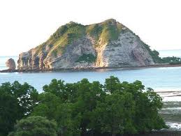
Mantis or promontory called by name
by the community Tepeleo Two Stone, District Patani. has beautiful natural
scenery and can be reached by land vehicles as far as 7 km. This place is
surrounded by white sand and beautiful coral forms, suitable for swimming and
diving activities.
Another island into a tourist attraction is the island Makian, one of the islands that once ruled by the Portuguese as a result cengkihnya. In this island there is also precisely in the village of Fort Mauritius Ngofakiaha founded by Pieter Both sekirar 1609 when the Portuguese came to North Maluku. Fort about 400 yards wide and on the island also has a volcano named Kie Besi.
Kayoa Islands is a cluster of islands that tourists visit the very interesting because in almost every island has a variety of beautiful coral and marine life as well as the type of fish is quite a lot.
In this archipelago of the most
visited by tourists is the island Lelei and Gura Ici due around the island has
fine white sand and beautiful sea garden perfect for swimming and diving.
Other islands are the Obi Islands are one of the island, Pulau Sambiki also suitable for the activity of swimming, diving and fishing trips and cruises can be visited.
Other islands are the Obi Islands are one of the island, Pulau Sambiki also suitable for the activity of swimming, diving and fishing trips and cruises can be visited.
Morotai
Island during World War 2 is one of Japan's
main military base in this region before the Allies captured and used by
General Mc Arthur as a basis to develop strategies to attack Allied forces
throughout the Pacific region.
Currently the island with human
settlements scattered in an area of 1600
km2 has tourist sites of great waters for diving and snorkeling as well as
relics of World War 2. Morotai Island has the form of a flat surface.
Dodola island is uninhabited island
located in front of Daruba, South Morotai. The island is surrounded by white
sand in length of 16 km can be reached by motorboat from Daruba. Besides this
island there are other small islands around it such as the Island Kokoya,
Ngele-ngele and-Galo Galo.
Mc Arthur teletak hideout on the
island of Sum-sum front Daroba capital city of South Morotai sub-district. The
distance is about 15 miles long and can be reached by boat or speed boat. On
this island General Mc Arthur, who led in World War II in hiding.
buildings can still be seen and the
rest of the tools of war are still found there such as guns, cannons, pistols
and even framework of aircraft and used car wars. At this location became the
Allied Forces against Japan's defense.

Bacan
Islands are offshore in the southern tip of
Halmahera. Bacan Island is the largest island in the archipelago followed by
Kasiruta Island and Island Mandioh. Bacan Island is the most developed island
has facilities for tourists as well as a transport hub in the region.
Labuha
is the greatest kora Bacan Island
and in the back of a Protestant church there are the tourist sites of the
Portuguese fort Bernaveld built to withstand the advance of Spanish in the
region. The fort was then occupied the Netherlands in 1609 and surrounded by a
moat and a few cannon because it was mentioned as one of the most interesting
fortress in the Moluccas.
Kedaton
Sultan Bacan was originally the residence of the
Shah but Muksin kedaton arena that was built before Sultan Sadik Shah in the
18th century have been destroyed by World War II, then the residence of the
local people called the Milky Kedaton also functioned as the central government
is Sultan Bacan.
Kedaton now has been amended several times, the last renovation in 2003 by replacing the roof of his house, while the shape and the authenticity of the building will be retained.
Sultan
Bacan Mosque was built during the Sultanate
Bacan held by the Sultan Usman Shah late 18th century. He built upon his return
from Soleman Asamadani studied with Sheikh, a scholar who banished the Dutch
from Java to Ambon.
Based on the spirit of religious
symbols of Islam, he built this mosque in addition to also build a madrassa in
the village Amasing Bacan, which until now still can be used for public
worship.
Sources: Tourism Information Book Archipelago Ministry of Culture and Tourism Republic of Indonesia
Sources: Tourism Information Book Archipelago Ministry of Culture and Tourism Republic of Indonesia
No comments