South Sulawesi

South Sulawesi
administratively bordered with Central Sulawesi province in the north and west
by the Straits of Makassar. Bounded on the east by the Gulf of Bone and the
south with the Flores Sea. The capital of Makassar with a strategic position in
Eastern Indonesia allows South Sulawesi can function as service centers for
both the Eastern Region of Indonesia or to an international scale.
Geographically, the Straits of
Sulawesi (Makassar) is known as the boundary of the Wallace line, telling the
two sets of different wildlife, namely the eastern and western parts of
Indonesia. Species of flora and fauna of this island is as specific as ebony
wood, pigs, deer and birds butung maleo colorful with large eggs.
Its government is divided into 18
districts namely Bantaeng, Barru, Bone, Bulukumba, Enrekang, Gowa, Jeneponto,
Luwu, Luwu North Luwu, Maros, Pangkep, Pinrang, Polmas, Selayar, Sidrap,
Sinjai, Soppeng and three cities each Makassar , Pare-pare and Palopo.
Before the proclamation of the
Republic of Indonesia, South Sulawesi, consisting of a number of independent
kingdoms territory and inhabited by four ethnic groups, namely: Bugis,
Makassar, Mandar and Toraja.
There are three major kingdoms wide
influence of Luwu, Goa and Bone, which in the sixteenth and seventeenth
centuries to achieve glory and conduct of trade relations and friendship with
Europeans, Indians, Chinese, Malay and Arabic.
In 1530, the Kingdom of Gowa began to
develop themselves, and in the mid-16th century Gowa became important trade
centers in eastern Indonesia. In 1605, King of Gowa embrace Islam and make
Islam as the Kingdom of Gowa. Between the years 1608 and 1611, the Kingdom of
Gowa Kingdom rnenaklukkan Bone attack and so Islam can be spread to all parts
of Makassar and Bugis.
Dutch trading company, better known
by the name of VOC (Vereenigde Oost-Indische Compagnie) who came to this area
in the 15th century to see the kingdom of Gowa as an obstacle to the desire to
control VOC spice trade in this area. VOC then allied with a prince named
Whitewater Palakka Bugis who lived in exile after the fall of Bugis under the rule
of Gowa.
Holland then returned to the Bone
Palakka sponsors, as well as turn on Bone and Sopeng community resistance
against the power of Gowa. After fighting for a year, the Kingdom of Gowa were
defeated. And King of Gowa, Sultan Hasanuddin Bungaya forced to sign Treaty
which greatly reduces the power of Gowa. Furthermore, under Palakka Bone became
ruler in South Sulawesi.
Makassar and Bugis community
resistance against colonial kckuasaan continue until the year 1905-06. In 1905,
the Dutch also managed to conquer the Tana Toraja, the resistance in this area
continued until the early 1930s.
Residents of South Sulawesi consists
of four main ethnic tribe the famous Toraja has a specific cultural, religious
nuanced look at the ceremonies of death, a traditional house with curved roof,
carving a beautiful and natural color.
Makassar tribe, known as the Bugis
and Mandar sailors good patriotic days of war and future peace. With a
traditional sailing boat across the sea islands of Indonesia to northern Australia,
some islands in the Pacific Ocean to the coast of Africa.
Large areas of South Sulawesi
province is a mountainous area lush verdant. In this area there are a variety
of natural beauty such as waterfalls, lakes and caves that are interesting
attractions to visit. South Sulawesi has a fertile soil in which crops such as
coffee, cotton and sugarcane became the mainstay commodities other than rice
plants of this area.
District Takalar
District Takalar
Talakar District is an area that has the potential of tourism is supported by the state of nature, society, culture and social condition of the business world. The potential of tourism in the District and objects that can be developed Takalar classified into nature tourism, culture, history, agro tourism and marine tourism. Galesong terkenat with the potential of fisheries, marine and flying fish egg producer has been a major export commodity.
Was awarded a beautiful stretch of
scenery in addition to low-and high land, was also awarded the expanse of ocean
stretching region. Takalar local government does not seem to waste the
blessings of nature by developing coastal tourism Lamangkai including agro-tourism
activities mango Klom manifold over an area of 2000 Ha.
The wealth of the region's coast that
is now the top priority of tourism development. As a first step has targeted
the development of Sanrobengi Island,
a small island of white sand has various unique advantages as well, such as
residents call vang only occupied about 10 families semenrara relatively close
to the beach Losari Makassar.
For ease of transportation to the island Sanrobengi, the Government has increased functionality in the Region Bodclia dock, in addition to TPI (Fish Landing Place) and the landing ship goods from Kalimantan. Dock it also can be operated as a port of Marine.
Another object of the beach is a Topejawa beach located in the Village
Topejawa about 14 km from the city Takalar or 54 km from Makassar. This beach
is famous for its beautiful expanse of sea and has been equipped with various
facility for vacation.
The Tanakeke island is a tourist attraction other marine district owned by the beauty of coral reefs and is known as the sea horses and sea birds that live in mangrove forest areas. In addition there are seagrass that grows in white sand and coral reefs.
This tourist attraction is located in
the village of deer hunting and Ko'mara Barugaya. Distance to this location
about 23 km from the city Takalar and can be reached through land route
approximately 50 minutes. Deer hunting is an activity that is often done by
Karaeng (nobility) in these two villages. In addition to hunting deer, mountain
scenery, waterfalls, lakes and forests complement the beauty of the tourist
attraction in this area. Even sports activities like rock climbing and so forth
can also be performed in these attractions.
District Bantaeng

Geographically Bantaeng District bounded on the North sebetah Bulukumba Gowa and, in the south with the Flores Sea. The eastern boundary with Bulukumba and in the West with Jeneponto District.
Bantaeng is Bugis shipbuilding center with a famous reputation for hundreds of years. This area is rich in maritime history. In the past, Bantaeng was conquered areas (colonies) kingdom of Majapahit. Poems of Java in the 14th century had praised the quality of this area of artificial vessels. In the North Bantaeng there is a pretty impressive waterfall. Here tourists can do sports activities beach, shower or bathe in the sea or sailing a boat. Along the coast are fishing boats can be hired for traveling along the coast. A number of natural and cultural attractions are a mainstay among other surroundings Stone White Sand Beach is located in the Village Baruga, Pajukukang District, about 18 kilometers and the City Bantaeng.
Way there can be taken approximately
30 minutes, passing the road axis in the direction Bantaeng Bulukumba. This
white sand beach located not far from the highway. Visitors who traveled there
on a motorcycle or car.
Mount Forest Tourism Workshop is located in the village of Bonto Marannu, Uluere District, about 24 kilometers and the City Bantaeng. Way there can be taken approximately 90 minutes, passing Bissappu district with the conditions of winding roads and climbs. Visitors can watch the corn crop planted on hillsides. Here it was cool, because it is above the altitude region. And from the highway visitors have to walk about 1 kilo meter to reach Forest Workshop tours.
Not far and jungle tours, there is a
gym called Loka Camp for outbound
activities. Among the path that is passed, there is a plantation area of vegetables planted in between cabbage and carrots. Here there are
facilities for sports such as gliding, walking on the rope, and walk in atasj
meshes.
In the village of Kampala, District
Eremmerasa, about 16 kilometers and there Bentaeng City Baths Eremmerasa nature. Way there can be taken approximately 30
minutes. Along the way tourists can see houses on stilts lined up in between
the rice field. Around this bath was cool with the natural scenery of hills
covered with trees and green plants.
There are two swimming pools as much
as two pieces, each for adults and children. This pool has a water source and
the mountains and between the two pools there is a stage for performances or
performances of the event. Around the pool, there is a stream of flowing water
and the mountains among the rocks and form a small waterfall.
Bissapu Waterfalls at Village Bonto
Salluang, District Bissappu, about 5 miles and the City Bantaeng. Way there
should be done in the morning or before noon. Along the way, you can feel the
cool air with the natural scenery of green trees on either side of the road.
After arriving at the destination location, you can watch the teak trees around
the waterfall,
To be able to see the waterfall,
visitors must walk through the tiered steps down. The scenery around the
waterfall was naturally arranged. All around there are places to rest, there is
a large stone that can be used as seats.
In the City of Bantaeng., Precisely
in the Village Tappanjeng, there Bantaeng District have Seruni Beach, can be
reached within 5 rnenit pass road axis. Here there anchor the dock where
fishing boats or boats carrying goods. Kavu dock this afternoon when a place to
relax among the young. Nearby there is a cafeteria, a place that sells food and
beverages as well as presenting music.
Not far from the pier, along the
coast, there is a seat made of walls extending from East to West. Many young
people who likes to hangout here. Sitting on the beach in the afternoon while
waiting for the sunset to be set, is a sight that can be found every day.
Another object of the beach is a Lamalaka beach, located in the Village
Lembang, Bantaeng District, located in Bantaeng City Sightseeing is also
reachable within walking distance of the inn in the city Bantaeng. Children who
live in the vicinity of this beach soccer activities usually perform in the
evening, a scene which adds to the rise of the beach.
In Bontojaya Village, District Bissappu, about 16 km and the City Bantaeng. There Ejaya Batu Caves near the village chief Bontojaya Office. From a distance this cave in sight, because it was on a flat hill, located about 300 meters from the highway.
Around the cave there are a lot of
cottonwood trees. Local people using the fruit of the kapok tree as raw
material for making mattresses. Batu Caves Ejaya been investigated in 1937 by
Van Stein Callonfols, scientists from the Netherlands. He did archaeological
excavation and stone tools rnenemukan calsedon flaky type which is used as
pencerut, the ends of the arrow.
Old Mosque Tompong also become one of the object visited by tourists. Located at Jalan
Bantaeng Bolu, which is in the Village Letta, District Bantaeng. And the City
Bantaeng, through the streets of Makassar-Bantaeng shaft.
The mosque has a roof uno form
overlap tjga. Building parent body composed of the viewer and the mosque. The
walls of the mosque in the North, South, and West made of walls and air vents
that have a roster of green porcelain, wall of the mosque in the eastern part
consists of four pillars with architects and Europe.
It is said that this mosque was built
in 1887 on the initiative of King Bantaeng Karaeng Panawang of the 12th
century. A benefactor of the District Wajo named La Bandu and settled in
Bantaeng at that time to assist in the construction of the mosque by an
architect named La Pangewa imported from Bone regency.
Tomb Kings La Tenri Ruwa is a tomb complex located in downtown Bantaeng, precisely in
the Environment Lembang China, Village Pallantikang, District Bantaeng. All
around there are people's homes. Approximately 50 meters east of this tomb
complex contained Calendu River. At the location of this complex there are
ornamental plants, paths, ponds, lawn chairs, information space, bathroom and
WC. Bantaeng tomb kings are taken from an historical figure of La Tenri Ruwa
whose tomb is in the complex is He is the king-11 Bone to the first received an
invitation from the King of Gowa-141 Mangerangi Daeng Manrabbia Sultan Alauddin
to embrace Islam, the complex this building there are about 159 pieces of
building the tomb. Tomb building materials made of coral stone, the rest rocks,
bricks and limestone using adhesive
Tourism in the city can also mengunjungj Bantaeng Lompoa Balla, a typical custom home Bugis-Makassar where bermukimnya Bantaeng kings in earlier times. Its land is approximately 1617 square meters. The building consists of the main house and pavilion.
Sinjai District
Sinjai District is an area that is located on the eastern coast of the southern peninsula of South Sulawesi and is in the Foot of Mount Bawakaraeng, saving potential of marine tourism and nature tourism because the scene was no less interesting to other areas.
Sinjai District is an area that is located on the eastern coast of the southern peninsula of South Sulawesi and is in the Foot of Mount Bawakaraeng, saving potential of marine tourism and nature tourism because the scene was no less interesting to other areas.
In addition, as the former area of the joint between the kingdom Tellulimpoe (Tondong, Bulo Bulo, and
Lamatti) with the Kingdom Pitulimpoe (Turungeng, Manimpahoi, Feels, Pao,
Manipi, and Bala Suka Suka), must save the relics as a sign of the triumph of
the second kingdom in the past. This is a potential for cultural tourism is no
value.
Development potential is essential in
order to support this region as one tourist destination after Tana Toraja and
Bira (Bulukumba) which has long been recognized by the international community.
The objects of tourism, among others,
Stone Pake Gojeng Archaeological Park, Pulau Sembilan, House Karampuang
Antiquities, Old cemetery Caropo, Baruttunge Falls Twin Falls, and rice paddies
terassering surta Passion Fruit plants.
For the development of marine tourism
potential areas for marine tourism activities are nine islands in the District of
North Sinjai. Lasia beach on the East and the Village Keeamatan Sinjai
Parrongko Tellulimpoe District.
Nine island
consists of nine islands which Burungloe Island, Island Liang liang, Kambuno
Island, Island Kodingare, Batanglampe Island, Island Katingdoang, Kanalo Island
1, Island and Island Larearea Kanalo 2 which is a potential area to be used as
a marine tourism object.
Lokasl is located approximately 9 miles from the Port lappa and can be reached by using a vehicle with a motorized boat travel time about 1 hour, or a speed boat and takes about 15 minutes.
Lokasl is located approximately 9 miles from the Port lappa and can be reached by using a vehicle with a motorized boat travel time about 1 hour, or a speed boat and takes about 15 minutes.
Range of 9 pieces of the island is
partly hilly area is beautiful scenery in the middle of the sea. Diversity of
corals and reef fish is the main attraction for diving activities, and fishing.
Underwater scenery and Bungingtallue Hellopute Hirst is also a commodity that can be offered. Calm inviting waters tend to perform activities of paddle sports and water skiing. Panoramic coastal Larearea Island is uninhabited small islands with white sand potential to be developed to enjoy the sunshine (sunbathing activities),
Underwater scenery and Bungingtallue Hellopute Hirst is also a commodity that can be offered. Calm inviting waters tend to perform activities of paddle sports and water skiing. Panoramic coastal Larearea Island is uninhabited small islands with white sand potential to be developed to enjoy the sunshine (sunbathing activities),
There are many other unique things
like fresh water wells in the area of the ups and downs
P. Burungloe and table
corals in P. Kanalo II. In addition, Panorama sun rises in the sea and setting
behind the mountains can be seen if it is in the surrounding area of this island (Setup).
Balangnipa fort
is 2 km from the center of Sinjai, located in the village Balangnipa, District
of North Sinjai. At the start of construction (1560), this fortress is the
basis that the material is a volcanic rock which was tied by Tangka River mud,
thick walls siwali reppa (half fathoms), rectangular and has four defenses
(bastion). Later in the Dutch colonial era (1864), renovated by architect
European model, and completed in 1868.
Barru District

Barru is one of the regencies in South Sulawesi, which has a region that lies on the coast of Makassar Strait, stretching from South to North direction along approximately 78 km. Barru Pangkep District bounded by the South Makassar Strait in the west, Pare-Pare on the North and East District Soppeng in sebeleh.
Have the potential areas that can be
developed that is tourist beach / nautical, nature tourism and cultural tourism
/ history. Baharinya sights are on coastal areas and islands in Barru who have
gardens are quite beautiful sea accompanied by white sand.
Antata other beaches and the island
of Cape Coast Butung Putianging located in the Village District Lasitae Tanete
Rilau. There is also a stone beach in the Village Lemoe uiung Sumpang Binangae,
District Barru. Pannikiang island beach in the Village District Madello Balusu,
Dutungnge Island, Island in the Village Palanro Bakki, Kecarnatan Mallusetasi.
Kupa Beach and other coastal Mallusetasi Marine Park and Beach Labuangnge and
Stone Village Mallopie in New Bojo, Kecarnatan Mallusetasi.
For natural attractions are generally
located in mountainous areas that have adequate water resources with a lot of
beautiful natural scenery dotted with shady trees. Sights include waterfalls
and rock Mallopie Wae Saie in the Village district Lompo Riaja Tanete Riaja,
Hope Valley Hope Village District Tanete Riaja.
Bantimurung Waterfall and the panorama of nature Jempulu Village District Pujananting
Pujananting. Bottoe River district. Tanete Rilau, Waterfall Village Tompo Pangi
valley district. Beautiful Lajulo Barru Caravan Village District Tuwung Barru.
Hot springs village Kalompie galung Barru District. Waeng Pubbu bath, Goa Tegenra in the
Village District Madello Balusu. Paccekke scenery, the Village District
Paccekke Soppeng Riaja. Bujung Mattimbawae in the village of Nepo and
ecotourism activities in the Kupa Mallusetasi District.
Barru is one area in South Sulawesi
Tourism has a considerable history. Custom home Saoraja Lapinceng is one of
historical / cultural past, this house made in 1895 during the reign of King
Balusu Andi Muhammad Saleh held Dg.Parani Sulle Petta.
It is against the background by the
many leaders of freedom fighters who were born and destined to be present in
this region. Object history can be seen Tomb We pance Land, tomb We Tenri Olle,
Tomb Lamaddussila Village District Pancana Tanete Rilau.
We Tenri Leleang tomb, the tomb of
Petta Pallase Lasee, an old mosque in the village Lalabata Lalabata Tanete
Rilau District., Tomb H. Muh. Fudail in Sumpang Binangae Barru district.
Monumcn Garongkong and Complex Maridie ground tombs in the Village District
Mangempang Barru.
Lapinceng Traditional House in the Village Balusu Balusu District. Monument Paccekke
Village District Paccekke Soppeng Riaja, Lagonggo Tomb complex in the Village
Mallawa and tomb complex in District Court Mallusetasi nephew.
Polmas District
Polmas District also known as boat Sandeq as one type of traditional boats Mandar tribe Austronesian heritage from the time of migration in the 15th century BC. This boat is a type of boat with a length of 5-16 meters bercadik that can be used to catch fish up into the deep sea. No wonder that type of boat is a means of transport between provinces for the purpose of Java, Borneo, even down to Malaysia and Madagascar, Africa.
Polmas District also known as boat Sandeq as one type of traditional boats Mandar tribe Austronesian heritage from the time of migration in the 15th century BC. This boat is a type of boat with a length of 5-16 meters bercadik that can be used to catch fish up into the deep sea. No wonder that type of boat is a means of transport between provinces for the purpose of Java, Borneo, even down to Malaysia and Madagascar, Africa.
Maritime tourism is a mainstay on the
Gusung Toraya island of policing in
the District Binuang that can be taken approximately 75 minutes from Pier
Sappang. Recreation area with a panorama of beautiful beaches and the clean
white sand. The island is flanked by the island Karamasang, Tosalama Island,
Island and Island Panampeang Battoa.
Riso Natural Park located on a hill in the mountain village region Riso, District Tapango.
Tourist park has an area of approximately
11,000 hectares with the cool mountain air and has a number of species of butterflies. Another
attraction of this tourism is a protected forest and irrigation water source.
Customary and traditional home appliances policing in the village signs Saratu, District 400-year-old Mamasa is a unique ancestral heritage and includes traditional equipment used in tribal Mamasa time immemorial. Tedong-tedong grave is one of the cultural attractions that are not less interesting.
Tedong-tedong this is one of the
tombs dating back some 400 years old made of wood shaped like a buffalo. In the
language Mamasa tedong buffalo is the framework that contains a human cadaver.
Ceremonies are conducted for people who have died in policing is a traditional
ceremony called Pangngaroan or Solo signs or ceremonies of grief / death.
The ceremony at the Village nosu,
Pana District about 75 miles from the capital of policing is generally for the
royal line. The bodies are stored first in the house for months and even years
until the family could carry out this ritual with the sacrifice of pigs and
buffalo.
Wajo District
Wajo District has an area of 4.01% of the total area of the Province. South Sulawesi, is administratively divided into 14 districts consisting of 45 villages and 131 villages, divided into four dimensions of hilly land, plains, lakes and seas. Hilly land stretching from South to North. Lowland is located in the East, South, Central and West. The lake is located on the west coast while stretched in the east overlooking the Gulf of Bone along 103 km of coastline.
Wajo District has an area of 4.01% of the total area of the Province. South Sulawesi, is administratively divided into 14 districts consisting of 45 villages and 131 villages, divided into four dimensions of hilly land, plains, lakes and seas. Hilly land stretching from South to North. Lowland is located in the East, South, Central and West. The lake is located on the west coast while stretched in the east overlooking the Gulf of Bone along 103 km of coastline.
Sengkang is located on the Lake Tempe
who has a beautiful panorama, Sengkang is a pretty nice city to visit. One
appeal of Sengkang is the product of silk weaving that is the result of the
people.
Sengkang is
known as a center of silk industry. Silk fabrics are sold in Sengkang market
like silk scarves silk weaving center, but unfortunately belongs to the people
generally located in the villages around Sengkang who do not have access to
public transport. To be able to go into these villages, you should hire a
public transport.
Tempe Lake is
a lake that is broad but shallow enough that a bird habitat. Edge of the lake
is an area of mud which is also
the local shelter.
Visitors can stroll along the lake by boat motors up to the River Walanae,
visited the village and the village of Batu Batu Salotangah in the middle of
the lake.
Lake Tempe is located at the West
District Wajo. Precisely in the District of Tempe, about 7 km and city of
Sengkang to the banks of the River Walanae. From this river, a trip to Tempe
Lake can be taken approximately 30 minutes by boat motors (katinting).
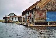
Nuanced Bugis fishing village lined
the edge of the lake. Fishermen who catch fish in the lake area of 13,000 hectares with a background of floating houses, is a very
interesting sight.
From the heights, Tempe Lake looks like a giant basin is flanked by three districts namely Wajo, Soppeng, and Sidrap. While relaxing on the boat, tourists can watch the sunrise in the eastern horizon in the morning and sets in the western horizon in the evening. In the middle of the lake, we can witness a variety of birds such as grouse, who grabbed the fish that appears above the water surface of Lake Tempe.
From the heights, Tempe Lake looks like a giant basin is flanked by three districts namely Wajo, Soppeng, and Sidrap. While relaxing on the boat, tourists can watch the sunrise in the eastern horizon in the morning and sets in the western horizon in the evening. In the middle of the lake, we can witness a variety of birds such as grouse, who grabbed the fish that appears above the water surface of Lake Tempe.
This lake has a freshwater fish
species that are rarely found in the tain. That said, the bottom of the lake is
the source of fish food store, which is estimated to have anything to do lies
the lake which is above the slab of two continents, namely Australia and Asia.
Agro Tourism Silk Road became one of the mainstays in the district. Mulberry planting stage
to the process of making silk fabrics have long been the main attraction for
tourists visiting the District Wajo.
Location seeding and planting
mulberry located in several villages in the District Sabbangparu, about 10 km
south Sengkang Town, District menuiu Soppeng road axis.
Here, visitors can witness the process of planting mulberry, how to raise silkworms, silk yarn spinning process, to how to weave silk fabric. Special products in the form of silk cloth, gloves, shirts, ties, and various forms of souvenirs from silk fabric and bags sperti fan.
Some silk showroom in Sengkang Town provides a variety of colors and motifs macarn beautiful. Motifs are much in demand Bugis society generally motifs and motifs that resemble Toraja carvings.
Traditional House Atakkae cultural area located in the Village Atakkae, Tempe
District, built in 1995 on the Lake Lampulung, about 3 miles East Sengkang
Town. Within this area has built dozens of traditional houses duplicates
collected from various kecamacan, so this area as a place representative of the
exhibition.
All around the building as a place to
stay there traveler, near the lake. Almost every year, this cultural area
visited by tourists, especially when held a variety of cultural attractions and
folk games.
In the region built a custom home,
dubbed larger Tenribali Saoraja-palace,
one of matoa Wajo. The house was rnempunyai pole as much as 101 pieces. Each
pole weighs 2 tons, ironwood from Kalimantan.
The pole was set up with heavy
equipment (excavators). Circle of 1.45 m pole house with a diameter of 0.45 m,
and height of the pole from the ground up to the attic 8.10 m. This custom home
building has a length of 42.20 m, width 21 m and 15 m high ridge
Kalola Dam area,
is a tourist area located in the village of Sogi, Alaniangpajo District, about
35 miles north Sengkang Town. Region which occupies an area of 65 hectares is always crowded by tourists.
Kalola dam contained in this tourist
area has puddles of water discharge 21.5 km with 900 m3 per second, stretching
between the mountains of rocks overgrown with trees shady, cool, and very
exciting.
We can watch the fishing activities by local residents by boat wheels. Tourists can also fishing, rowing race, skiing, and enjoying the beautiful scenery around the dam.
Visitors are usually held the camp and about 3 km from the dam has been built swimming pools and boarding. For those who like to hunt, can channel his hobby, because there is a park near this location hunting deer.
The location is about 5 km from the
dam Kalola, precisely in the village of Sogi, District Mamangpajo. Garden area
of 500 hectares of forest were very representative
for those who have a hobby of hunting. In the past, people hunt deer with horses and hounds.
In fact, the level of courage and maturity of a nobleman's son at that time measured by the ability and agility they catch deer. For those who like the adventure, hunting deer is one alternative.
In fact, the level of courage and maturity of a nobleman's son at that time measured by the ability and agility they catch deer. For those who like the adventure, hunting deer is one alternative.
That location can be reached by using the 4 whell drive car because the road leading to the site is a sloping hill. In the surrounding landscape looks with green grass surface, flanking the broad field hunting. Around this park there are small rivers and trees on the sidelines of the valley as a supporter of wildlife deer.
Tosora site is
located approximately 16 km in the east of the City Sengkang. Precisely in the
Village Tosora, District Majauleng. J.okasi can be reached by motorbike or car.
Tosora is the former capital of Wajo around the 17th century.
This region is surrounded by 8 pieces
of a small lake. Many historical and archaeological relics found here, such as
the tomb of the kings Wajo, former ammunition warehouse kingdom (geddong),
ancient rnasjid built in 1621, and the tomb of the bernisan cannon.
Here also there is a bung wells parani, ternpat past soldiers bathed before plunging into battle. Many tourists who have visited here. Their motivations varied, among them came just to make a pilgrimage. Others come to remove loose or azar, and there is also a history of conduct assessment.
Here also there is a bung wells parani, ternpat past soldiers bathed before plunging into battle. Many tourists who have visited here. Their motivations varied, among them came just to make a pilgrimage. Others come to remove loose or azar, and there is also a history of conduct assessment.
Here also there in the mountains of
the eastern city of Sengkang. The location is not far from the Grand Mosque
Sengkang. Visitors can walk to this location, especially those who are happy
with the adventure.
Nippon Cave of tunnels created by the
Japanese army as a hiding place and the defense in World War 2. The amount is
not less than 10 pieces, but now some have been terturup soil naturally.
Inside the cave there is a very spacious room. Local people believe that the cave as a place where the treasure left behind by Japanese soldiers, and in time of war as a base defense of South Asia.
Mouth of the cave has an average
diameter of about 1 meter. When visitors want to get into the cave, they have
to bend or crawl. There is a cave entrance is different from the way to go out.
Some of them, the entrance and exit to the cave is only one lane.
At night, tourists can stay at
houseboat. Together with fishermen, we can see the moon at night that lit up
while fishing Lake Tempe.
Meanwhile, the fishermen catch fish
accompanied by traditional music played by the population. On 23 August each
year, a calendar of activities implementation sea festival in Lake Tempe. These
fishing party ritual or a ceremony called Maccera Tappareng purify the lake
with the organization of various tourist attractions are very appealing.
On the day of the Lake Festival
Tempe, all participants wore ceremonial Maccera Tappareng Bode (custom clothing
Bugis). The event was also enlivened with many attractions such as the
traditional boat races, boat races decorative, folk game contest (traditional
kite competitions, the selection of virgin and Land kallolona Wajo), the race
beating Iesung (padendang), performances of traditional music and dance played
by transvestites bissu , and various other traditional performances.
Paddle boat race is a tradition
handed down and preserved among the fishermen. While Maccera Tappareng is a
form of ritual activities conducted on the Lake Tempe by the people who live on
the edge of Lake Tempe. usually characterized by sacrificial cutting / cow
headed by a chief fisherman, and a spate of other events.
Tana Toraja District
No doubt Tana Toraja is a popular tourist destination of the most interesting and most famous in Sulawesi. Geographically, Tana Toraja in South Sulawesi, the base of the peninsula and covers an area of considerable Iuas. In this area you will find beautiful scenic traditional villages with rice fields that stretched Iuas, tongkonan traditional house building with unique architecture and culture of Toraja is very interesting.
No doubt Tana Toraja is a popular tourist destination of the most interesting and most famous in Sulawesi. Geographically, Tana Toraja in South Sulawesi, the base of the peninsula and covers an area of considerable Iuas. In this area you will find beautiful scenic traditional villages with rice fields that stretched Iuas, tongkonan traditional house building with unique architecture and culture of Toraja is very interesting.
One of the most impressive custom
event in Toraja is the burial ceremony which was famous throughout the world.
Toraja people believe without funeral rites, the spirit of the dead that will
provide misfortune for the family left behind.
The highlight of this burial usually
takes place in July and August. At that time the Toraja people from all over
Indonesia will return home to participate in this event. The arrival of people
from overseas Toraja was followed by ribanya tourist arrivals to see the unique
culture here.
Toraja society ethnographically can be divided into three groups: Toraja West, East and South, but a little known outside the particular foreign tourists are South Toraja also known by the name Toraja Sa'adan or Saqdan and generally live in and around the capital Rantepao and Makale Tana Toraja administration. This beautiful little town surrounded by hills that peak is often covered with fog and near the town there is an artificial lake.
Toraja society ethnographically can be divided into three groups: Toraja West, East and South, but a little known outside the particular foreign tourists are South Toraja also known by the name Toraja Sa'adan or Saqdan and generally live in and around the capital Rantepao and Makale Tana Toraja administration. This beautiful little town surrounded by hills that peak is often covered with fog and near the town there is an artificial lake.
Rantepao is the largest city in Tana
Toraja, and also trade in the region. Tourists who visit the Toraja generally
congregate in Rantepao. The city is a starting point for tourists who want to
explore all the uniqueness and beauty of Toraja. Rantepao is the city of rain
because rain is almost always falls throughout the year with the cold air at
night.
Rantepao has a
huge market, but trading activity carried out only once a week, one of which is
the Market Bolu. The market is located about 2 km in the North East Rantepao is
interesting to visit because it became a meeting place Toraja people who come
from different places in the region.
Botutumonga is
a small city situated on the slopes of Mount Sesean, about 20 km in the North
Rantepao, has a beautiful panorama. From this altitude view of the city lies
Rantepao and Sa'dan Valley located in the distance at the foot of the mountain.
From this place, tourists can also enjoy the beautiful sunrise and take a trip
(hiking) down Batutumonga region, then enjoy a meal in the restaurant and
overnight at the lodge are available in this city.
District Soppeng
Soppeng District is one of regencies in South Sulawesi Province. Soppeng Watan capital city also called fruit bats / bat. there are so many myths that are growing that the presence of these bats by the hundreds to thousands of these, perched in a tree-lined city park with a distinctive noise.
Soppeng District is one of regencies in South Sulawesi Province. Soppeng Watan capital city also called fruit bats / bat. there are so many myths that are growing that the presence of these bats by the hundreds to thousands of these, perched in a tree-lined city park with a distinctive noise.
The presence of bats in the heart of
the City Watansoppeng, further adds to the charm of this city, because the
capital city Watansoppeng dubbed the bat. Uniquely bats are only willing to
stay and swinging on branches throughout town Watansoppeng. As the sun sank in
the western horizon, bats are flying in search of food and before sunrise as
the dawn call to prayer echoes, bats it back into place with a distinctive
voice and noisy as the city woke Watansoppeng to start the activity. Lejja Hot
Water Baths is one of the mainstay attractions visited by many domestic and
overseas tourists. The bath is located in a hilly area of protected forest with beautiful natural scenery, cool, comfortable
in the Village Bulue, Marioriawa District, about 44 km north city that can cure
rheumatic diseases and itching.
Sightseeing is equipped with adequate
facilities and infrastructure such as clean water, electricity, parking lots,
paved roads, guest house, Swimming baths, tennis courts and Baruga travel to
meetings with a capacity of 300 people.
Ompo Nature Baths is one of the flagship tourist destination as well. Tertetak bathing in
the Village District Ompo Lalabata, about 3 miles north of the city known for
its water Watansoppeng clear, cold and a source of clean water to communities
and municipalities, and mineral waters processed by a national private company.
In this Ompo area attractions, there
are large areas for camping and Motor Cross and also there is an artificial
lake that is wide enough as a play area boats and freshwater fishing.
Natural baths are located in the
heart of the village of Citta Citta Liliriaja District, about 35 miles east
Watansoppeng city and about 15 km from Cangadi, the Capital District. In these
objects, visitors can swim and enjoy the beauty of natural scenery, villages
and the surrounding community activities such as processing of traditional
tobacco.
Villa Juliana is one of the buildings
in the District Soppeng Dutch heritage, the building is located in the heart of
the city was built by CAKrosen Watansoppeng in 1905 as governor of the Dutch
East Indies government in Sulawesi.
Construction and architecture of this
building is a blend of European style and the style of Bugis. This villa is a
twin building, one of which exist in the Netherlands, the construction of this
Villa is a form of love for the Queen Juliana.
Traditional House Village is located in Sao Mario Manorang Marioriawa Salo District,
about 30 km from the city Watansoppeng. Traditional House in the complex Sao
Mario, there are various types of traditional house-style architecture Bugis,
Makassar, Mandar, Toraja, Minangkabau and Batak.
This custom home also serves as a museum with a collection of various types of high-value antiques from various regions in Indonesia and overseas such as: Chairs, Tables, Beds, Sharp Weapons and various gemstones macarn.
Datu Soppeng Palace Complex is situated in the heart of Watansoppeng dealing with
Juliana Villa built around the year 1261 during the administration of King
Soppeng I Latemmala Bakkae title Petta.
In the complex there is construction,
among other Ridie Ball (Yellow House), which serves to store various types of
attributes royal, Salassae, serves as the Palace Soppeng data, Menhir
Latammapole serving as a place for people who violate the customary manner
around 7 times.
Jera Lompo tomb
is the tomb of Datu / Kings Soppeng, Luwu and Sidenreng of the XVII Century.
The tomb is located in the Village District Lalabata When about 1 mile north of
the city Watansoppeng. Looking at the shape, orientation and type of historical
data can be said that the tomb is the tomb of Islam around the XVII century,
but seen from the tomb there is the influence of Hindu culture.
District Luwu
Luwu the area bounded by North Luwu and Tator District in the north, of Bone and Wajo the south, the Gulf of Bone and Provinsl Sultra in the East and also bounded by Regency Tator, Enrekang and Sidrap. Like other regions natural attractions and cultural tourism in the form of grave sites also be seeded.
Luwu the area bounded by North Luwu and Tator District in the north, of Bone and Wajo the south, the Gulf of Bone and Provinsl Sultra in the East and also bounded by Regency Tator, Enrekang and Sidrap. Like other regions natural attractions and cultural tourism in the form of grave sites also be seeded.
Luwu the Royal Palace also called Batara Guru Museum, for example, located in downtown Palopo.
The palace was founded in 1922-1924 by a Dutch architect named Obsenter Noble
in the Dutch colonial period in Luwu with European-style buildings.
The palace that serves as a museum of
this Guru store personal items and equipment that was once used Luwu Kings.
Here too there are antiques such as ceramics, tools and equipment ceremonial
and heirlooms.
Tomb Kings Luwu (Lokkoe), which means cave retreat. Located in downtown Palopo and
uniquely shaped like a pyramid shape. In this place are buried the kings who
had dominion Luwu.
Andulan Cave in the village of Liang Siteba, Lamasi District has a variety of stalactites
and stalagmites with beautiful colors. To reach the cave visitors must go
through about 480 steps and inside the cave there are ancestral graves Lalong
To Tana consists of Kabongian Liang, Liang Sugi, Liang Salikuku.
Other objects are natural attractions such as Latuppa, Wara District, a three-tiered waterfall with a natural ambience that is cool and the surrounding protected forest.
Bone Pute beach in District Larompong is equally interesting as a fine white sand and tropical fish that are found so well suited for fishing activities.
District Jeneponto
Geographically, the area bounded by Regency Jeneponto Gowa and Takalar District in the north, the Flores Sea to the south. While the eastern boundary with Bantaeng District and in the West: District Takalar. As in other districts in South Sulawesi, Jeneponto district also has a tourist attraction visited by many foreign and domestic tourists.
Beach tourism is located in the
Village of Hope Island in the west district Mallasoro Jeneponto. Having a
beautiful natural scenery and lush with shady trees. Sloping beach with a
comfortable air to perform various activities olaharaga beach.
Object lairinya beach is Birtaria
Kassi in District Tamalatea with a gently sloping beach and is well ordered,
supported a variety of swimming pool facilities. lodging, fishing pond and a
variety of restaurants, souvenir shops and children's entertainment arena.
Boro Waterfall
is located in the Village District Tompobulu Kelara or 20 miles from the city
Bontosunggu, the capital of Jeneponto. Beautiful scenery with pegubungan
located on either side of the waterfall that reaches 20 meters height.
Tombs of Kings Binamu are the tombs
of the kings who had ruled in Binamu Turatea Jeneponto Butta. This cemetery has
a level that can be seen from the statue which is above the grave and the
available space information and guard the tomb site to serve the tourist
visits.
Sources: Tourism Information Book Archipelago Ministry of Culture and Tourism Republic of Indonesia
Sources: Tourism Information Book Archipelago Ministry of Culture and Tourism Republic of Indonesia
Full info visit:
http://www.fatawisata.com/wisata-nusantara/sulawesi/sulawesi-selatan?start=10
No comments